
- Home
- Kakome Bay
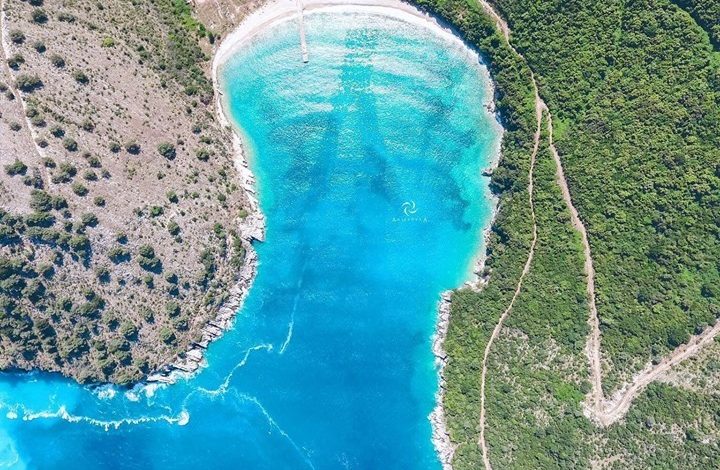
Kakome Bay: A Hidden Jewel of the Albanian Riviera
Kakome Bay is located about 13 kilometers north of Saranda, in a secluded area with a completely untouched beach nestled in a small bay. The surrounding area is lush and green, making it a very attractive destination for tourists seeking nature and tranquility.
A Natural Haven
Kakome Bay is a beautiful beach in Nivica, ideal for swimming and relaxation. There are no roads leading directly to the beach, so the only way to reach it is by boat. During the summer months, several boats along the Saranda promenade offer tours that include a stop at Kakome Bay. These boats usually depart around 9 or 10 in the morning, making multiple stops between Saranda and Krorëza Beach.
Kakome Bay remains one of the most unique and captivating attractions for both local and foreign visitors.
Geography and Landscape
Kakome Bay is situated 1.5 nautical miles WNW of Cape Qefali and extends 3 cables in a SSE direction, with a width of 1.5 cables at the entrance.
The eastern shore of the bay is low and sandy.
The northern and especially the southern shores are high rocky cliffs that plunge steeply into the sea.
The southern cliffs reach heights of 10–15 meters and are covered with forest, while the northern cliffs are sparsely vegetated.
The eastern shore also contains cultivated farmland.
In the northeastern part of the bay, two stone buildings are visible as you approach the inlet. A new tourist village is under construction here. Additionally, on the eastern shore, there are two freshwater wells, located 40 m and 65 m from the shoreline.
Sea Depth and Navigation
The bay is deep, with the northern shore being deeper than the southern.
On the northern side, the 5-meter isobath comes very close to the shore.
On the southern side, the 5-meter depth starts 8 m from the entrance and reaches 52 m at the end of the bay.
The eastern shore is characterized by an abrupt depth drop — just 5 meters from shore, the water is already 3 meters deep.
Deeper zones include:
10 m depth reaches very close to the shore (only 10 m) between the two capes at the bay’s entrance.
From the eastern shore, this depth is found 85–90 m out.
The 20 m isobath curves back towards the northwestern entrance of the bay.
The bay is free from underwater hazards, except for a partially submerged rock located in the southeastern corner of the bay, 8–10 meters from the shore, with surrounding depths of 2.9–3.4 meters — suitable for small boats.
Winds and Weather Conditions
The bay is well protected from southern, eastern, and partly northern winds.
However, it is completely exposed to northwesterly winds.
A characteristic of the bay is a strong eastern wind that blows through the large valley between the surrounding mountains. This wind often forms swirls, making it difficult for vessels to remain anchored. It is common in winter, but can also appear in summer.
Harbor Infrastructure
On the eastern shoreline, there is a concrete pier (jetty) built from east to west:
It is 52 meters long and 5 meters wide.
Southern side depths range from 0.2 m (east end) to 5.40 m (west end).
Northern side depths range from 0.2 m to 5.60 m at the western tip.
Currently, there are no navigational lights or signals to assist with docking. The pier is in need of repairs.
The pier connects to an unpaved road leading to Cape Qefali and to the main asphalt road Kakome–Saranda–Vlora via Qafa e Kopelit. About 5 cables WNW of the northern cape of the bay’s entrance lies another point of interest.